


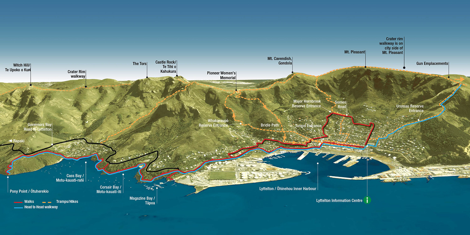
LYTTELTON Walks
A coastal meander with views over Lyttlelton port visiting historic sites, sandy swimming beaches and ending at the Pony Point Reserve. Ideal for families and part of the Head to Head walkway. Note the new track section from Cass Bay to Pony Point now goes straight up from the west end of Cass Bay towards the road, then traverses below the road to the top of Pony Point Reserve.
*Dogs on short leash on beaches 1 Dec-1 Mar 9am-7pm and at all times in Pony Point
Native bush, Coastal, Historic, Track formed, Sign posted, Road walking
- Lyttelton Harbour Information Centre, 20 Oxford Street, Lyttelton, 03 328 9093
- Department of Conservation – enquiries, 0800 275 362
- Download brochure
Dogs on short leash on beaches 1 Dec – 1 Mar 9am – 7pm and at all times in Pony Point.
Open
Explore the nooks and crannies that make the historical port town of Lyttelton so interesting. Some strenuous street climbs and uneven surfaces.
Native bush, Coastal, Summit, Historic, Track formed, Sign posted, Road walking
- Lyttelton Harbour Information Centre, 20 Oxford Street, Lyttelton, 03 328 9093
- Department of Conservation – enquiries, 0800 275 362
- Download brochure
LYTTELTON Tramps/Hikes
Open
For the nimble-footed who like scrambling up rocks and narrow cliff paths. This walk has magnificent vistas over Whakaraupō /Lyttelton harbour, Sumner and Christchurch. This tramp includes steep hill climbs that are on oat-like tracks and is unsuitable after heavy rain. Beware of rock fall danger.
Native bush, Summit, Sign posted
- Lyttelton Harbour Information Centre, 20 Oxford Street, Lyttelton, 03 328 9093
- Department of Conservation – enquiries, 0800 275 362
- Download brochure
Open
A bracing loop walk with great views that takes you up through Whakaraupo Reserve on the Stan Helms Track and back down the historic Bridle Path. This tramp includes steep hill climbs. Beware of rock fall danger.
Native bush, Summit, Historic, Track formed, Sign posted
- Lyttelton Harbour Information Centre, 20 Oxford Street, Lyttelton, 03 328 9093
- Department of Conservation – enquiries, 0800 275 362
- Download brochure
A tramp up the rugged, steep Major Hornbrook track, with fantastic views over Lyttelton/Whakaraupo Harbour and beyond Christchurch/Otautahi to the Southern Alps. Return via the historic Bridle Path. This tramp includes steep hill climbs. Beware of rock fall danger.
Native bush, Summit, Track formed, Sign posted
- Lyttelton Harbour Information Centre, 20 Oxford Street, Lyttelton, 03 328 9093
- Department of Conservation – enquiries, 0800 275 362
- Download brochure
This 1 km, 300m climb starts at Steadfast Reserve, Governors Bay Road in Cass Bay. Walk the 4WD track through Steadfast Reserve for 500m to the start of the poled route. The track climbs steeply to the Crater Rim walkway and Summit Road. The Steadfast Reserve gates are never locked. Click HERE for CCC website details.
Route warning: During winter tracks can be wet and slippery so please proceed with caution.
Native bush, Summit, Historic, Sign posted